
Parade route
Rosenmontagszug route, schedule, family zone, parking and safety notes.
ATTENTION! New Rosenmontagszug route
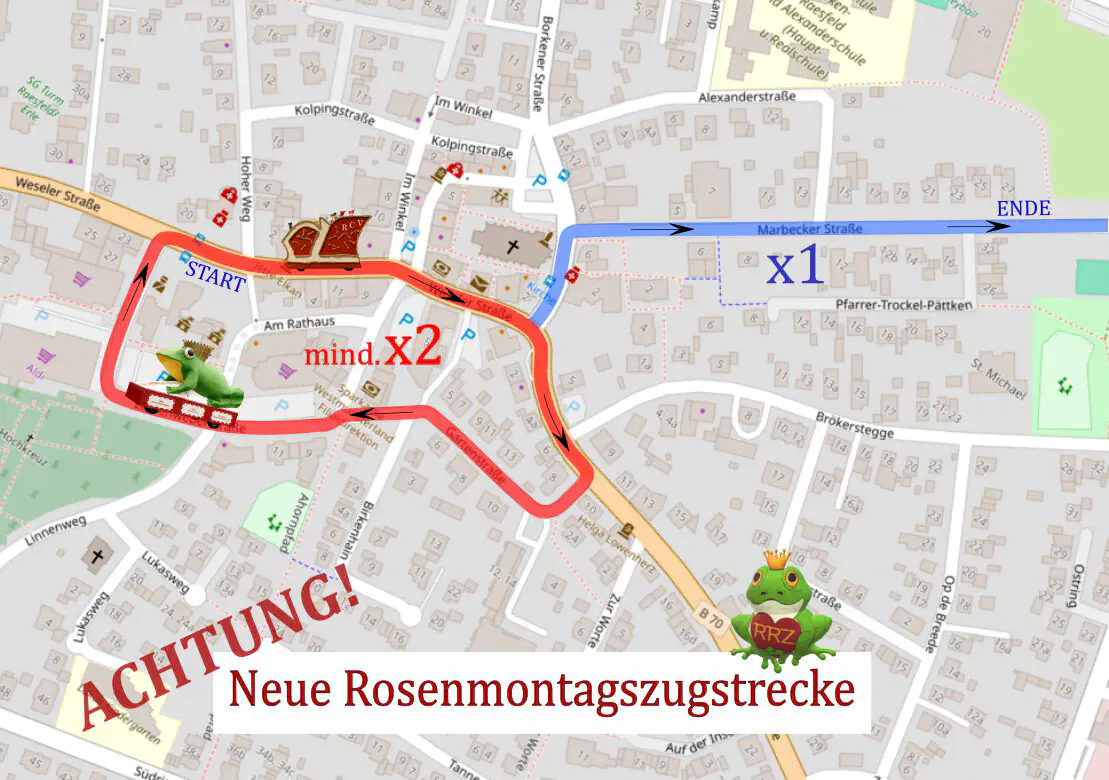
Open route in Google Maps The loop is drawn once in Maps (on the day: at least twice). Opening the link is subject to Google’s privacy policy.
The red loop is driven at least twice; the blue stretch (Marbecker Straße) once through to the end.
Route (as of session 2025/26)
Proven route — also planned for following years unless parade leadership and authorities approve otherwise:
- Start at the Rathaus
- Weseler Straße
- Dorstener Straße
- Gartenstraße — family zone with reduced music volume
- Leinenweberstraße (back towards the start; loop twice)
- Borkener Straße
- Finish Marbecker Straße (dismount; no party at the end point)
Commentators: corner of Borkener-/Dorstener Straße and the grandstand at the Rathaus.
Schedule Rosenmontag 2027
| Time | What |
|---|---|
| 11.33 | Departure from Anton to the Rathaus |
| 11.44 | Storming of the Rathaus |
| 12.33 | Start of the Rosenmontagszug from the Rathaus |
| afterwards | Tent party with DJ — Festzelt Zum Michael (Festwiese) |
Safety & infrastructure
- Cooperation with Polizei Borken, Ordnungsamt Raesfeld, DRK Raesfeld, Feuerwehr Raesfeld and a security service
- Access roads to the parade are closed
- DRK / first aid: among others, car park next to El Greco (as of session 2025/26)
- Several sanitary facilities along the route
- No glass and no confetti cannons — applies to spectators and participants
Details on rules and registration: Take part. Reports on the route: Press.
Parking & arrival
Please arrive early. Parking in the village is limited — use car pools where possible and the designated P areas (see map).
Details on parking zones and closures will follow once the municipality / parade leadership releases the final traffic plan.
Accessibility
Spectator areas along the route are generally level (pavements). A designated accessible area will be added here if available.
Questions about the route: parade leadership (see Board).